
We first trek Broga Hill in the early 2000's and the trail was not well marked or clear but it was during a hash run that we cross over the Broga Hill top. And at that mome nt about 60 hashers just stop at the 1st Stop (Broga Hill shapes like the back of a camel) and enjoyed the panaromic scenery, Broga Town below towards East and Semenyih Town towards West. It was windy and everyone sort of just relax. Off course the Broga Town locals and orang asli frequent this place often.
It used to be popular for the locals and orang asli as this place has many wild board hideouts, so they would come out here to hunt or trap them and on the fringe of this hill (secondary forest) many wild boar traps are laid. I have personally come across a few while trekking there. Usually a shallow hole is dug, then a steel snarl or loop trap is laid in the hole and covered (camouflage) with twigs, the steel wire is then tired to a strong bended branch or strong shaft. When bended and once trip or released it has a powerful springing action. Once the wild board steps into the trap it triggers the trap snarling one of its leg. Once in while you might find other kinds of wild animals trapped.
As people are aware of the benefits of exercise especially with nature (i personally don't like to exercise within four walls) Broga Hill has become a popular trek on weekends as seen by the number of cars park from inside the oil palm estate (private land). The owner so far have not complain publicly, good for us. So in return it is hope that every visitor keeps the place clean.
"Take nothing but photographs!. Leave nothing but footsteps!"There are 2 standard trails, if you a 'first timer' here, come on Sundays (before 6.45am) there will a regular group headed by Mr. Szeto, a middle age chinese trekker. He will be happy to show you the way. Normally he takes the back route going on the right through oil palm estate and then slowly snaking to the top through rubber estate route. For the normally fit this will take about 35 to 45 mins. And at the top along a ridge towards the left another 5 mins and viola! into a open area onto a big boulder to view the left side (Broga Town) and right side (Nottingham University Campus view ). From here onwards there are many view points for photography. The other route is on the left and straight up to Broga Hill view point 1, 2 and 3. This takes about 25 to 35 mins (normally fit). This other route especially if you need to view sunrise the trek should start around 5.30 am and only on clear skies.
After your climb there a few things you can do. Visit the rabbit farm just on the opposite side. Visit Broga Town for local breakfast at the coffee shop. Visit the Broga Rock Temple (Sek Dato). Visit Happy Fruit Land Farm. Well take your pick.
Durian season is around May to July. There are many varieties from the numbered one to the Jungle types. Broga Town is a closely knitted community of around 500 families. Life here is what you expect of a small town, practically everyone knows everyone and a nice place to relax.
Click on the play button to view a slide show of Broga Hill
Loading…
Take nothing but photographs!. Leave nothing but footsteps!

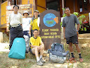
Registration at the Taman Negara office

Group photo - 5 members
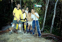
Wong with big tummy, Micheal with cap and YK & KC in yellow and our guide Man Panjang

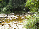
Scenic View Along Tahan River

Scenic view of river

1st campsite - Camp Melantai

Sipping Tea 'tarik'

Very early, still relaxing

Rest at Camp Tengah and having hot drink. hmmm

Camp Puteh waiting for Wong

Still Waiting

Still waiting for Wong, KC went for a dip

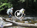
Crossing the 1st river to Camp Teku

2nd river crossing
Video River Crossing

Very wide river, shallow during dry season

Slow and steady to avoid falling

Coming! too far and you hardly can see me!

Lost count of the number of river crossed!

many many more to crosss

Very rocky river

Take a picture first and will wait for you at the other end

After Camp Teku, no more crossing river

Where is Gunung Tahan?

Camp Pangkin - very small and hardly can accomodate 5 tents

Man Panjang quickly has his tent pitched!

Adjusting, maybe can squeeze in another tent here!

When your group is big, not advisable to camp here

OK! time to go and get some water

Happy Birthday Michael (red t-shirt), fruit cake used as birthday cake

Another picture! once in a life time celebrating birthday at the highest mountain in West Malaysia

It was a suprise to Michael

Laughing at a joke
Group photo before leaving Pangkin campsite

One more with Man Panjang

Packing up going up the hill at background

Gunung Pangkin 1462M

couple photo

Ask Man Panjang where is G. Tahan again?

Wow! many many mountains to go!

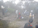
Steep Slope at Tangga Lima Belas

I am up here already!

Then you know why they named it Tangga 15

Hello! Hello! We are here! Always wear bright colour during climbing

Rest time and trying out handphone service

Next is to Gunung Reskit

Gunung Tanggga 15 (1848M)

These are wooded trail sign

Gunung Reskit here and next to G. Gedung

Michael took off his wet t-shirt

Tangga 15 another 4KM to Gunung Gedung

wild orchid

Scenic view from G. Gedung

More mountain views

Where is Gunung Tahan?

While waiting for Wong, we took photo using unfix trail sign

Here is G. Gedung and that way is to G. Tahan!

KC and Michael

One last one before they fix up the trail sign!

Another campsite down there - Camp Padang

Our last water point down there

I think that is Gunung Tahan

Cloud covering Gunung Tahan

Walking down to collect water

Here I am ready to scale the highest mountain!

Not even some shade to cover us during our lunch

At the top of another hill or mountain?

Very hot lah!

Background still can see the trail

Beautiful posing!

Almost there! A few more steps!

At last we are at peak!

Take another one in case

Couple photo

At last Wong is here !

Signing the our names in the log book

Michael turn to sign his name

I want a single shot!

Must take another couple photo

Michael was the 1st to reach the peak

Sunset at the background

Hardly can see YK, KC and Michael!

This one not clear!

This is a better one!

Here we are at the top of the highest mountain!

Sun covered by cloud

Beautiful sunset!

Misty morning cannot see sunrise what a miss!

Very, very cold!

A clearer shot because the cloud has gone

Hi, here is Gunung Tahan!

One way from Kuala Tahan and the other way from Merapoh
Packing up and getting ready to decent

Along the way a lots of white moss

Cooking our lunch at Teku
Teku river where Wong hurt his big toe on the 2nd night

Camp here after 12 hours trekking on the 2nd day

We are going to Camp Putih this way!

Camp Putih and ready to go Camp Melantai on the 7th day

Bye bye to Camp Putih!

Gunung Rajah 465M

2 hours from Camp Putih to Gunung Rajah

Here is Camp Tengah!

YK getting ready to get crystal clear water

Water collected through bamboo

Yk collecting water and photo taken by Michael

Waiting for Wong Camp Melantai

On the 8th Day going home

This fallen tree trunk is old and slipperry

Destroyed trail sign by elephants

Another 5KM to Kuala Tahan

Waiting for Wong again!

At last Wong showing 5KM sign to Kuala Tahan

Wong and Man Panjang at Camp Putih

Small pitcher plant

Gunung Pangkin 1462M

Man Panjang taking photo

Wong said 'I wish I can fly'

YK & KC

Wong resting at Gunung Tangga 15

Narrow trail

At the back were ropes

Group photo at the ridge

Bonsai tree

Wild orchid

View of plateau where we camped at peak

Wild flower

Beautiful High altitude plants

Wild flower close up shot

Gunung Tangga 15

KC coming up to Gunung Tangga 15

Wong coming up to Gunung Tangga 15

Gunung Pangkin 1462M

Resting at the peak of Gunung Pangkin

Where is Wong?

We are back to entry point at Kuala Tahan

Forgot to take this sign on the 1st day

Take nothing but photographs!. Leave nothing but footsteps!

Civilization at last!

Certificate for completing the climb from Kuala Tahan to Kuala Tahan

Group photo with certificate

Team photo with our guide

Team photo with Man Panjang

Another team photo taken!

Kuala Tahan floating restorant

Big makan here to celebrate the successful climb
No results found.
email ykkclow@gmail.com

 nt about 60 hashers just stop at the 1st Stop (Broga Hill shapes like the back of a camel) and enjoyed the panaromic scenery, Broga Town below towards East and Semenyih Town towards West. It was windy and everyone sort of just relax. Off course the Broga Town locals and orang asli frequent this place often.


4 comments:
Hi - I was trolling the web as I have a friend in Malaysia and was amazed at the clip with the ballet dancers - they were really good! I studied ballet for many years - Wondered where the dancers were from - and do they perform elsewhere? (I am in the US)
Ehr... They are from Kajang and no, not yet performing elsewhere.
Hi YK. Check out my new blog on Banting Town. I've set your link on my page. Regards...
For those who want to come to banting, visit
http://banting.wordpress.com/getting-here/
Post a Comment